Boise Idaho sits on a mix of Quaternary alluvial deposits from the Boise River and windblown loess on the benchlands, which creates variable foundation conditions for any road embankment design. Groundwater can be shallow near the river—sometimes within 3 to 5 feet of the surface—while the bench areas have deeper water tables but collapsible silt layers. We have seen fill placements fail because the native subgrade was not characterized before compaction. That is why we always start with a subgrade evaluation to define the existing soil modulus and moisture conditions before designing the embankment. Our team follows ASTM D698 for standard Proctor and ASTM D1883 for CBR to establish compaction targets that match the local borrow sources.
One compaction curve cannot serve both the river sands and the bench loess in Boise Idaho—each borrow source demands its own Proctor target.
Method and coverage
- Modified Proctor (ASTM D1557) for high-traffic embankments
- One-dimensional consolidation tests (ASTM D2435) to estimate primary and secondary compression
- Direct shear (ASTM D3080) on compacted samples to set the internal friction angle
Regional considerations
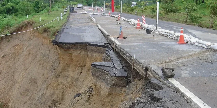
ASCE 7-22 and IBC 2021 require that embankments in Seismic Design Category C (Boise Idaho falls into SDC C for most of the valley) be evaluated for liquefaction and lateral spreading. The loose saturated sands along the Boise River are particularly susceptible to strength loss during a design earthquake. If the road embankment design does not account for post-seismic settlement, the pavement can crack or shift at the transition between fill and cut sections. We run cyclic triaxial tests (ASTM D5311) on representative samples to quantify pore pressure generation and recommend mitigation measures such as stone columns or deep soil mixing where the risk is highest.
Standards that apply
ASTM D698-12 (Standard Proctor), ASTM D1557-12 (Modified Proctor), ASTM D1883-16 (CBR), ASTM D2435-11 (Consolidation), ASCE 7-22 Chapter 11 (Seismic Loads)
Related services
Embankment Compaction Control
We perform field density tests (ASTM D6938 nuclear gauge or ASTM D1556 sand cone) and compare results against the Proctor curve for each lift. Our technicians issue daily reports showing percent compaction, moisture deviation, and corrective actions if the lift falls below 95% of maximum dry density.
Bearing Capacity & Settlement Analysis
Using consolidation and triaxial data from undisturbed samples, we calculate the embankment's long-term settlement and bearing capacity. This service includes a shallow foundation check for the pavement layers and an evaluation of differential settlement at culvert or bridge approach zones.
Typical parameters
Top questions
What is the typical cost for a road embankment design study in Boise Idaho?
The cost ranges between US$1,190 and US$3,600 for a standard study covering borrow source characterization, Proctor curves, CBR, and settlement analysis. Larger projects with multiple borrow sources or deep fill sections may exceed this range.
What soil types are common along the Boise River for embankment construction?
The river corridor contains loose silty sands and gravelly sands (SM, SP-SM) with occasional soft clay lenses (CL). The bench areas have windblown silt (ML) that is collapsible when wetted. Each soil type requires a separate compaction curve and stability check.
How deep does the investigation need to go for an embankment design?
Borings should extend at least 1.5 times the embankment height below the base of the fill, or until refusal or competent bedrock is reached. For a 20-foot embankment, we typically drill to 30 to 35 feet to capture the full settlement-prone zone.
Do you provide field compaction testing during construction?
Yes, our technicians are on-site daily to perform nuclear density tests and sand cone tests on each lift. We issue a daily compaction report that includes location, percent compaction, and moisture content compared to the project Proctor curve.